
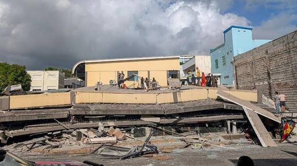
Two strong earthquake readings, measuring 7.2 and 6.9 in magnitude, were reported near the Vanuatu Islands in the South Pacific Ocean on Saturday, October 24. The reports came from the same general area within a gap of around 25 seconds, raising questions about whether the readings represented two separate earthquakes or different estimates of one seismic event.
According to a report by India Today, the first earthquake was recorded at a depth of around 10 kilometres. The second reading was also associated with a depth of 10 kilometres. However, the available information did not establish whether two distinct earthquakes had occurred. Further updates from monitoring agencies are needed to clarify the details.
The United States Geological Survey (USGS) separately reported a magnitude 7.2 earthquake in the waters approximately 200 kilometres west of Sola, a settlement in Vanuatu. The agency placed the earthquake at a depth of 10 kilometres below the Earth’s surface. Reuters also reported the same preliminary magnitude, location and depth based on USGS information.
Earthquake Recorded Off the Coast
The first reported epicentre was around 200 kilometres west of Sola. The second reading was associated with a location approximately 197 kilometres west-northwest of Port-Olry, another settlement in Vanuatu. Both locations are in the same broad part of the South Pacific.
Differences in preliminary earthquake readings are not unusual. Seismic monitoring agencies use information from monitoring stations to estimate an earthquake’s magnitude, depth and location. These estimates may be revised as more data become available. In this case, the close timing and nearby locations do not, by themselves, confirm whether the two readings represent separate events.
The distinction matters because the number of earthquakes, their exact locations and their final magnitudes help authorities assess possible effects and determine whether additional monitoring or public safety measures are needed.
As of the information available in the initial reports, there was no confirmed account of casualties, damage to buildings or major disruption in Vanuatu. The absence of confirmed reports should not be taken as proof that no damage occurred. Information from local authorities and emergency services would be needed to establish the impact on communities.
Tsunami Risk and Official Updates
The earthquake’s location beneath the ocean also made tsunami information an important part of the developing story. The Pacific Tsunami Warning Center issued a preliminary threat message after the magnitude 7.2 earthquake. It said potentially hazardous tsunami waves were possible along coasts within 300 kilometres of the epicentre, including parts of Vanuatu. The message advised authorities in potentially affected areas to inform and instruct coastal communities according to their own assessments.
A preliminary tsunami threat message does not mean that damaging waves have definitely formed or reached land. It indicates that the earthquake’s initial characteristics are sufficient to require assessment and precaution. Authorities use additional information, including sea-level observations and updated earthquake parameters, to evaluate the threat.
Residents in coastal areas should follow official instructions from local authorities and recognised tsunami-warning agencies. People should not rely on unverified social media posts to determine whether an evacuation is necessary. The latest local guidance is particularly important when information about the earthquake is still being updated.
At the time of the initial reports, details about the actual effects of the earthquake and the final interpretation of the two magnitude readings remained limited. Further official updates are necessary before drawing conclusions about the extent of any tsunami threat or damage.
Why Earthquakes Are Common in Vanuatu
Vanuatu is an island country in the South Pacific, made up of an archipelago east of Australia. The country lies in a seismically active part of the world where the movement of tectonic plates produces frequent earthquakes.
Earthquakes occur when stress builds up in rocks along faults and is released suddenly, sending seismic waves through the ground. Their effects depend on several factors, including magnitude, depth, distance from populated areas, local ground conditions and the strength of buildings and infrastructure.
A shallow earthquake can produce strong shaking near its source, although the actual impact varies from one location to another. When an earthquake occurs beneath or close to the sea, authorities also assess whether the movement could displace water and generate tsunami waves.
For Vanuatu, the immediate priority is to establish the event’s final parameters and assess any effects on coastal communities and infrastructure. Updated information from seismic monitoring agencies and local officials will help clarify whether the two reported readings were separate earthquakes and whether any damage or tsunami impacts occurred.
For now, the confirmed information points to a magnitude 7.2 earthquake west of Vanuatu at a depth of about 10 kilometres, while the relationship between the 7.2 and 6.9 readings remains uncertain. The situation should be followed through official updates as more reliable information becomes available.
